
Garadaoua Fm
Type Locality and Naming
The valley of Keita shows the most beautiful sections of this formation, particularly in the village of Garadaoua (Fig. 2). Dikouma, 1990. Group = Dallols Gr.
References: Monod, 1939; Kikoine, 1950; Faure et al., 1956; Greigert, 1966; Kogbe, 1973; Hanon, 1990; Dikouma, 1990, 1994; Moody et al., 1991; Givens, 1991; Carbonnel et al., 1994; Dikouma et al., 1993, 1994; Moody, 1997; Tintant et al., 2001; Moumouni et al., 2019; Laouali-Idi et al., 2021.
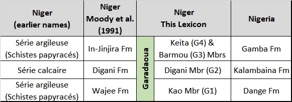
Synonym: Garadoua, Garadawa (both misspellings); "Termes 5, 6, 7" of Greigert (1966); "Série argileuse (Schistes papyracés)" at the top, "Série calcaire" at the center, "Série argileuse (Schistes papyracés)" at the bottom. Moody et al. (1991)'s formations of Wajee, Digani and In-Jinjira of Niger (Fig. 1).
Equivalent(s): Sokoto Gr in Nigeria. The G1, G2 and (G3 & G4) Members are the equivalent of the Dange Fm, Kalambaina Fm and Gamba Fm in Nigeria.
[Figure 1. Synonymy and equivalent names in Niger and Nigeria of the Garadaoua Fm.]
Lithology and Thickness
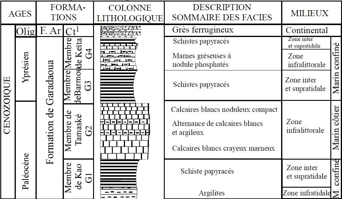
The base of the Garadaoua Fm is observed in Garadaoua village and is made of slightly indurated bluish-gray shale, interbedded with thin layers of yellowish-brown limestone. Greigert (1966) called the base and the top of the Garadaoua Fm “Schiste papyracé” (papyraceous shale) because of the very fissile nature of the two horizons. Dikouma (1990) divides the formation into three Members (from top to bottom) (Fig. 2):
- Keita Member (G4); Transgression T6 and regression: Laouali-Idi et al. (2021) highlight this fourth Member. The first level of this Member is marly, sandy with a conglomerate tendency and contains a fauna of bivalves, foraminifera, and ostracods. It is associated with the first Ypresian transgressive episode. The second level is made up of papyraceous schists qualified as the second Ypresian regressive episode.
- Barmou Member (G3); Regression: This Member is represented by a level of papyraceous or cardboard shales. It corresponds to the first regressive Ypresian episode.
- Tamaské Member (G2); Transgression T5: It includes three limestone levels of varying thickness, forming cliffs with rectilinear borders. The base level is made up of shaly fossiliferous limestones. The intermediate level is represented by massive limestones rich in fossils (such as gastropods Lyrischapa soudanese (Givens, 1991) and ostracods (Carbonnel et al., 1994). The summit corresponds to chalky and nodular limestones. This set represents the Paleocene transgressive episode.
- Kao Member (G1); Regression: The base level is represented by yellowish argillites, very fossiliferous, comprising nautiloids, echinoids (genus Linthia), bivalves and gastropods. The upper level is essentially made up of papyraceous shales. This Member corresponds to the Paleocene regressive episode.
The maximum thickness is reached in the Keita region, where it exceeds 70 m. It gradually decreases towards the south, where it is reduced to around 20 meters at the Niger-Nigeria border.
[Figure 2. Section of the Garadaoua Formation at Garadaoua village (Source: Laouali-Idi et al., 2021).]
Relationships and Distribution
Lower contact
Underlying unit is the In Wagar Fm
Upper contact
Overlying unit is the Ader-Doutchi Fm
Regional extent
GeoJSON
Fossils
Very diverse: bivalves (Glyptoactis (Baluchicardia) sp, Ostrea, Anodonta), echinoids (Linthia soudanensis), gastropods (Velates sp., Thersitea sp., Gisortia sp., Lyrischapa soudanese (Givens, 1991), nautiloids (Deltoidonautilus molli, D. sudanensis, D. chudeaui, Cimomia nigerensis) and foraminifera (Ranikothalia).
Age
Depositional setting
The environment of deposition is a perirecifal environment protected both from the arrival of continental detrital material and from the incursions of an oceanic biophase. The small size of the lamellibranchs of the Barmou Member (G3) indicates that the marine environment is becoming more and more confined, the beginning of the Eocene already announcing the emersion of the region.
Additional Information
This formation has been mined for cement both in Niger and Nigeria for decades for the quality of the limestone it contains. The Marine sequence is well exposed in the Tahoua area of Niger.
Faure et al. (1956) discuss a formation within the text of their work on pages 48 and 64 without mentioning its name. It is believed to describe the Garadaoua Fm at a time when the name had not yet been selected:
Limestones are located above the Maastrichtian and probably the regressive Danian (?). This stage passes in the “Sudanese strait” (between the Niger loop and the Adrar des Iforas), and it is well known in the region of Asselar (Tilemsi), where Th. Monod described a section (1939); it is characterized by Ostrea laperrinei var. pseudobellovacina Roger. In Niger, it extends into Ader Doutchi Fm.
Towards the base, one observes beds with Turritellas, phosphate sands and phosphate gravels with vertebrates.
Kikoine (1950):
Ocher or chalky clayey limestone, silicified limestone, sandy marls, clays. Thickness: 5 to 30 m depending on the area.
Formerly attributed to Montien [Selandian]
Lower limit: Paleocene clay-sandy.
Upper limit: probable Lutetian papyraceous schists.
Main significant fossils: Gisortia "brevis" Douvillé, Heligmotenia molli Douvillé, Velates schmideli Chemnitz, Chenopus dimorphospira Coss. & Piss., Athleta thebaica Cuvillier, Operculina canalifera d'Archiac, Lockhartia haimei Davies.
Basin characteristics: Numerous Nautiloids (N. molli Douvillé, etc.) Linthia sudanensis Bather, Plesiolampas saharae Bather, Pseudoheligmus nigeriensis Newton, Panopaea sahariensis Newton.